Raptor Maps collaborated with Enel, DJI, and UVT to conduct the first-ever DJI Dock solar site inspection in North America. Conducted on a 180+ MWdc site, Raptor Maps built the necessary mission planning software to direct the drone to conduct the inspection.
 Utility-Scale Drone-in-a-Box Inspection
Case Study from | Raptor Maps
Key Takeaways
Enel, DJI, Raptor Maps, and Unmanned Vehicle Technologies (UVT) collaborate to achieve technological breakthrough for the solar industry.
Enel Green Power, a multinational provider of electricity and gas, has collaborated with DJI, Raptor Maps, and UVT to conduct the first-ever utility-scale solar farm inspection in North America with the DJI Dock (also known as “drone-in-a-box” technology). The achievement marks a major milestone for both the solar and UAS industries, enabling the solar industry to take advantage of this game-changing new technology.
Enel conducted the landmark inspection at a 181 MWdc solar site in Texas, demonstrating the Dock’s ability to facilitate inspections on a utility-scale site.

Image provided by DJI
DJI, a leader in enterprise drone solutions, developed the DJI Dock and Matrice 30T (M30T) Dock Version drone, while UVT, one of the largest North American drone & robotics end-to-end solutions providers, provided both the Dock and the deployment services for Enel’s testing. Raptor Maps, a leading provider of solar asset management software solutions, built the necessary mission planning software to direct the M30T drone to conduct the inspection.“We’re proud to have conducted the DJI Dock’s first-ever North American solar farm inspection at an Enel site,” said William Badnaruk, the Head of Industrial Risk and Cross Technology Improvement at Enel North America. “We believe this technology is the future of solar site inspections because it enables us to discover issues and inefficiencies more quickly, which will ultimately reduce our operating expenses and improve production at a faster rate.”
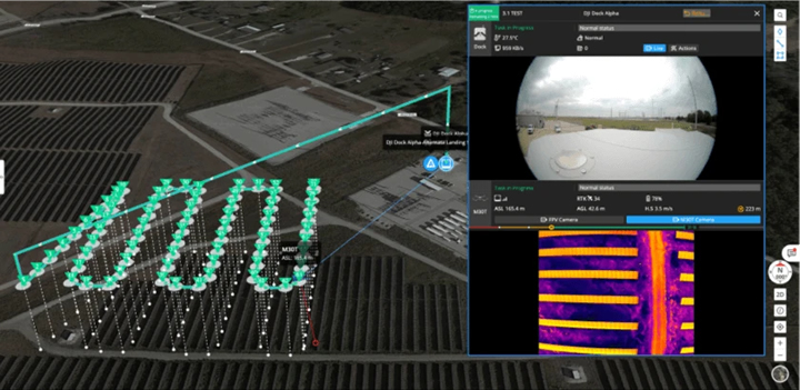
Image Credit: DJI. DJI Dock control interface through FlightHub 2
Drone-based aerial thermography has become the go-to method for inspecting utility-scale solar quickly, efficiently, and safely, but until now it has still required human intervention. Drone-in-a-box (DIAB) is ushering in a new era of automated and easily repeatable inspections, made possible by recent advancements in hardware, software, and operational planning.“One of the exciting things about the solar industry is that we get to drive new technology forward, and building the software for this drone-in-a-box inspection marks a significant innovation that will help the industry scale,” said Raptor Maps Cofounder and CTO Eddie Obropta.DIAB inspections allow for quicker identification and remediation of equipment-driven underperformance, which was found to have cost the solar industry $2.5B in lost revenue in 2022. Expediting inspections and repairs reduces safety hazards and fire risks, lowers costs for utilities and asset owners, and boosts revenue.

Image Credit: DJI. DJI Dock and the M30T ready to deploy from the rooftop
“There are a lot of operational considerations, such as pilot access to the site, data offload, and on-site flight planning, that are simplified with the DJI Dock,” said Grant Hosticka, DJI’s Head of Enterprise Solutions Engineering, North America. “The Dock automates operations and allows for repeatable methods of data collection, which we believe will change the face of solar inspections.”Moreover, with automated, AI-directed drone flights, DIAB technology ensures power production is attained to its full potential – eliminating waste in the energy value chain, ensuring a more reliable flow of clean renewable energy, and ultimately furthering American energy security.“This is truly a groundbreaking use of drone technology for the solar industry, and UVT is excited to have provided the crucial operational support and personnel for the deployment of the DJI dock on site,” noted Chris Fink, Founder & CEO at UVT.
Interested in learning more about how Raptor Maps can enable this technology for you?
About Enel Green Power
Enel Green Power, within the Enel Group, develops and operates renewable energy plants worldwide and is present in Europe, the Americas, Africa, Asia and Oceania. A world leader in clean energy, with a total capacity of more than 59 GW and a generation mix that includes wind, solar, geothermal, and hydroelectric power, as well as energy storage facilities, Enel Green Power is at the forefront of integrating innovative technologies into renewable energy plants.
About Raptor Maps
Raptor Maps is building solar’s integrated operating system, enabling the industry to scale and meet global climate goals. With intelligence for the entire solar industry, our solar lifecycle management platform (Raptor Solar) provides the tools and the system of record that asset owners, managers, O&M, developers, and EPCs need to build, maintain, and expand their solar plants. At the core of the platform are continuously evolving, geo-referenced digital twins of your solar assets, which integrate with the data sources you need to derive actionable insights. Raptor Solar bridges the gap between insight and action, improves asset health and power production, reduces risk, and ultimately increases the rate of return of solar assets. To learn more about Raptor Maps or to schedule a demo, contact us.
About DJI
Since 2006, DJI has led the world with civilian drone innovations that have empowered individuals to take flight for the first time, visionaries to turn their imagination into reality, and professionals to transform their work entirely. Today, DJI serves to build a better world by continuously promoting human advancement. With a solution-oriented mindset and genuine curiosity, DJI has expanded its ambitions into areas such as agriculture, public safety, surveying and mapping, and infrastructure inspection. In every application, DJI products deliver experiences that add value to lives around the world in more profound ways than ever before.
About UVT
UVT equips organizations nationwide with the latest in drone and robotics technology, training, and support. We partner with you to provide end-to-end turnkey solutions custom-tailored to your mission. Our comprehensive services include a diverse catalog of vetted enterprise hardware and software solutions, consultation, site surveys, installation, and education for seamless deployments. All of this backed by a suite of technical and operational fleet support services to help your organization maximize the benefits of our technology. To learn more, visit our website at www.uvt.us.
The content & opinions in this article are the author’s and do not necessarily represent the views of AltEnergyMag

Raptor Maps
Raptor Maps is building the integrated operating system for the solar industry, enabling the industry to scale and meet global climate goals. With intelligence for the entire solar industry, our solar management platform (Raptor Solar) provides the tools and the system of record that asset owners, managers, O&M, developers, and EPCs need to build, manage, and operate their solar sites. Raptor Solar improves asset resilience and energy yield, reduces risk and costs, and ultimately increases the rate of return of solar assets.
![]()
![]()
Other Articles
Rapid Assessment of Wind Damage
Aerial Thermography Findings from the Field: The Lesser-Known Impact of Shading on Power Production
Using Digital Twins to Improve Solar Farms
More about Raptor Maps
Comments (0)
This post does not have any comments. Be the first to leave a comment below.
Featured Product